New York environmental agency uses fleet of drones to monitor ecosystems across state
Courtesy of Gary McPherson
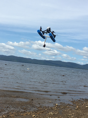
Drones have been used to help monitor the water quality of upstate New York lakes and creeks.
The New York State Department of Environmental Conservation last month announced it would release a fleet of 22 drones to help monitor ecosystem management, conservation and emergency response efforts across the state.
One of those drones was used in the Syracuse area last month.
The department recently used a drone to survey mudboils in the southern watershed of Onondaga Creek, known as the Tully Valley, said Benning DeLaMater, a DEC public information officer, in an email.
The mudboils discharge high levels of sediment into Onondaga Creek, which affects its water quality. Since Onondaga Creek is a major tributary that flows into Onondaga Lake, monitoring mudboil activity closely at its source is crucial, DeLaMater said.
Gary McPherson, an environmental engineer with the DEC, flew the drone over Onondaga Creek to monitor mudboils in mid-September.
The mudboils are relatively cool compared to the surface of the water, McPherson said. The drones aerially map the area to look for temperature differentiations that would indicate the presence of a mudboil.
Compared to previous methods, drones are a much more useful and convenient way to monitor a habitat aerially, McPherson added.
“The only way of doing this in the past was by aircraft, which was very cost prohibitive,” he said. “Drones are compact and can be flown much closer to the surface of whatever you are studying, which allows for greater accuracy in surveying.”
Several other drone monitoring missions have been completed in other parts of the state, according to a press release by the DEC.
The day after the announcement of the program, New York state Gov. Andrew Cuomo sent three drones to assist the New York Power Authority with restoring power in Puerto Rico and various emergency response missions, according to the press release.
There are no official plans to deploy drones over Onondaga Lake as of yet, DeLaMater said. It may be possible, though, to use drones to map and document the lake’s habitat restoration efforts, he added.
McPherson said he thinks drone surveying is here to stay. He said he looks forward to seeing other ways that this “eye in the sky” monitoring method will be used around the state.
Published on October 17, 2017 at 8:40 pm